
Pune Ring Road Project 2026: Route, Map & Latest Status
Pune Ring Road Project: The Pune Outer Ring Road is one of Maharashtra’s major infrastructure projects, aimed at reducing traffic congestion in Pune and Pimpri-Chinchwad and improving connectivity between major highways, industrial areas and neighbouring districts. The project is being developed in eastern and western corridors, with the Maharashtra State Road Development Corporation (MSRDC) responsible for the outer ring road.
As of October 2026, construction is progressing on the western corridor, while additional approvals and land acquisition remain important milestones for the eastern corridor. The state government has also approved a revised expenditure of approximately ₹10,502 crore for a 31.805-km eastern stretch, bringing the reported overall project cost to approximately ₹53,213 crore.
In this guide, we explain the Pune Ring Road route, map, villages along the alignment, construction progress, expected completion dates and the latest available official updates.
Pune Ring Road Project: Key Details
| Project detail | Information |
|---|---|
| Project name | Pune Outer Ring Road |
| Implementing agency | Maharashtra State Road Development Corporation (MSRDC) |
| Project type | Access-controlled greenfield road |
| Main corridors | Western and Eastern |
| Total planned length | Approximately 169 km, subject to alignment revisions |
| Western corridor | Urse to Varve Budruk/Shivare area |
| Eastern corridor | Urse to Solu and onward towards the Pune-Solapur/Pune-Satara highway connections |
| Latest reported overall cost | Approximately ₹53,213 crore |
| Western corridor target | December 2027, as reported in September 2026 |
| Eastern corridor target | December 2028, as reported in September 2026 |
| Current status | Western corridor under construction; eastern corridor progressing through approvals, land acquisition and development |
Note: Project lengths, budgets and timelines may differ across documents because of revised alignments, additional packages and changes in administrative approvals. The figures above reflect the latest available reporting and should not be treated as a guarantee of completion.
Pune Ring Road Latest News and Updates – October 2026
The Pune Ring Road project has seen several important developments during 2026.
1. ₹10,502 crore approval for an additional eastern stretch
In September 2026, the Maharashtra government approved an expenditure of approximately ₹10,502.36 crore for a 31.805-km stretch between Soratapwadi (Valti) and Varve Budruk (Shivare).
The stretch was initially associated with the National Highways Authority of India (NHAI). The state government decided to transfer its development to MSRDC because the work had not been taken up by NHAI on the required priority basis.
The approval includes civil construction and land acquisition costs. However, the project must satisfy prescribed land acquisition conditions before the construction contract can proceed to the relevant implementation stages.
According to reporting published by The Indian Express in October 2026, this additional expenditure takes the overall project cost to approximately ₹53,213.39 crore.
2. Western corridor construction progressing
The western corridor is one of the key sections of the project, intended to provide an alternative route for traffic travelling around Pune instead of passing through the city.
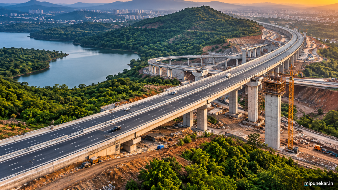
A September 2026 report by The Bridge Chronicle, citing MSRDC, stated that construction had reached approximately 30% completion. The agency’s reported targets were to achieve 65% completion by December 2026 and open the western stretch to traffic by December 2027.
These are reported targets, not confirmed opening dates. Actual progress will depend on construction, land availability and other implementation requirements.
3. Major tunnels and bridges under construction
The western corridor includes significant engineering works such as tunnels, bridges, viaducts, interchanges and underpasses.
One major component is the bridge across the Khadakwasla reservoir. The project also includes a tunnel in the Sinhagad region, intended to help the road cross the hilly terrain of the Sahyadri range.
These structures are important to the route because they allow the road to cross difficult terrain while maintaining relatively uninterrupted traffic movement.
4. Eastern corridor requires further development
The eastern corridor includes connections towards Solu, the Pune-Alandi/Markal road and the Pune-Solapur highway, as well as additional sections connecting towards the Pune-Satara highway.
The September 2026 approval for the Soratapwadi–Varve Budruk stretch is a significant administrative milestone. Nevertheless, approval does not mean that the entire eastern corridor is complete or open to traffic.
Land acquisition, project packages, construction contracts and the availability of required permissions will determine the actual delivery schedule.
Latest status summary: The western corridor is under construction, while the eastern corridor continues through a combination of construction, approvals and land acquisition processes. Travellers should continue to use existing roads until individual sections are officially opened.
Pune Ring Road Route: Where Will It Pass?
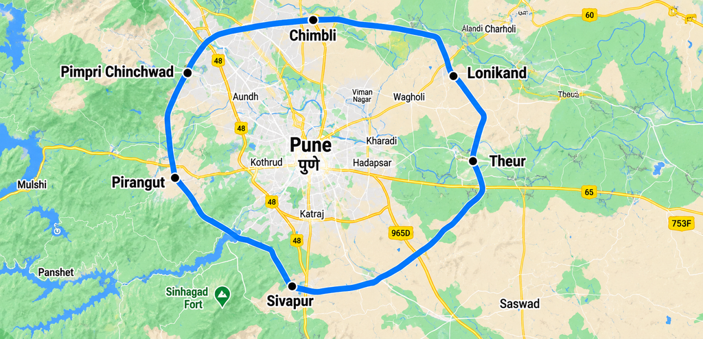
The Pune Outer Ring Road is planned to form a large loop around Pune and Pimpri-Chinchwad. Instead of forcing vehicles to travel through the city’s congested internal roads, the route is intended to connect major highways around the urban region.
The alignment is broadly divided into two main corridors.
Western Ring Road route
The western corridor connects the Urse area near the Mumbai-Pune Expressway with the Varve Budruk/Shivare area near the Pune-Satara highway.
Its planned route passes through or around the western and southwestern outskirts of the Pune metropolitan region.
Important route references include:
- Urse and the Mumbai-Pune Expressway connection
- Western Pune and Mulshi-side sections
- The Sinhagad and Khadakwasla region
- The Varve Budruk/Shivare connection near the Pune-Satara highway
The corridor is expected to help vehicles travelling between Mumbai, western Maharashtra and destinations towards Bengaluru avoid entering central Pune.
The exact village-level alignment should be checked against the approved MSRDC alignment map, especially for land acquisition or property-related decisions.
Eastern Ring Road route
The eastern corridor is planned to connect the Urse area with Solu and continue towards the eastern and southeastern outskirts of Pune.
Important route references include:
- Urse and the Mumbai-Pune Expressway
- Solu and the Alandi-Markal road connection
- The Pune-Ahmednagar Road/Nagar Road region
- The Soratapwadi area and Pune-Solapur highway connection
- The Varve Budruk/Shivare area and Pune-Satara highway connection
The eastern corridor is particularly important for vehicles travelling between industrial areas, the Pune-Ahmednagar highway, the Pune-Solapur highway and the Pune-Satara highway.
The route is designed to improve regional connectivity rather than serve as a road through the centre of Pune.
Pune Ring Road Map: How to Check the Official Alignment
People searching for the Pune Ring Road map should distinguish between a conceptual route map and the detailed approved alignment used for construction and land acquisition.
The following resources can help.
1. Pune Outer Ring Road alignment documents
The OpenCity Pune Outer Ring Road document collection provides alignment resources for the western corridor and the eastern sections. It includes KML map data that can be explored in compatible mapping applications.
Map resources: https://data.opencity.in/dataset/pune-outer-ring-road-documents
2. MSRDC official website
MSRDC publishes project documents, notifications and land acquisition records relating to the Pune Ring Road.
Official website: https://msrdc.in/
3. PMRDA Inner Ring Road information
For the separate Pune Inner Ring Road project, including technical specifications and land acquisition details, consult PMRDA’s official project page.
Official project page: https://www.pmrda.gov.in/en/inner-ring-road/
How to view the route in Google Earth
If you want to explore the alignment geographically:
- Open the Pune Outer Ring Road document collection linked above.
- Look for the western or eastern alignment KML resource.
- Download the relevant KML file, where available.
- Open Google Earth and import the downloaded file.
- Zoom in to examine the proposed road alignment in relation to villages, highways and existing development.
Important: A KML alignment is a mapping reference, not proof that every parcel shown is acquired or that every section is under construction. For property transactions, compensation matters and exact boundary questions, rely on the latest approved plans and official land acquisition records.
Pune Outer Ring Road vs Pune Inner Ring Road
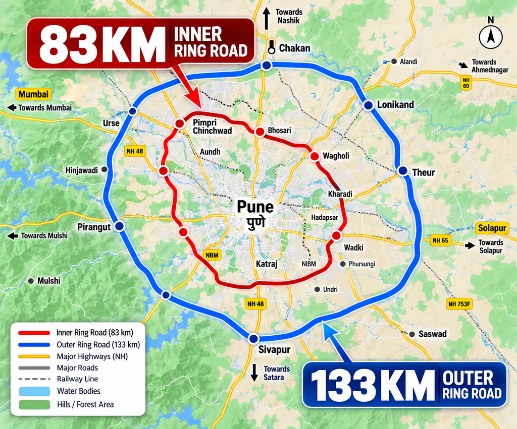
These two projects are often confused because both are intended to improve traffic circulation around Pune.
However, their implementing agencies, planned lengths and development stages differ.
| Feature | Pune Outer Ring Road | Pune Inner Ring Road |
|---|---|---|
| Implementing agency | MSRDC | PMRDA, with sections involving other agencies |
| Main objective | Regional traffic movement around Pune and Pimpri-Chinchwad | Improve urban and metropolitan connectivity |
| Planned alignment | Large outer loop connecting major highways | More closely associated with the urban and peri-urban area |
| Key infrastructure | Greenfield highway, tunnels, bridges and interchanges | Planned road network, tunnels, bridges and interchanges |
| Status | Major western construction works underway; eastern development continuing | Land acquisition, clearances and development processes continuing across sections |
PMRDA’s official page lists the Inner Ring Road at 83.12 km, with an administrative approval of ₹14,200 crore. It also describes a planned connection involving Solu Interchange and Vadgaon Shinde, with land acquisition and forest clearance processes under way for the relevant stages.
These figures belong to the Inner Ring Road project and should not be combined with the Outer Ring Road’s length or budget.
Which Areas and Villages Will Benefit?
The benefits of the Pune Outer Ring Road are expected to extend across the wider metropolitan region rather than being limited to one locality.
Western Pune and Pimpri-Chinchwad
Areas connected to the Mumbai-Pune Expressway and the western corridor may benefit from improved access to regional destinations. The route is also expected to provide an alternative for traffic travelling towards Mumbai without passing through busy urban roads.
Mulshi and the Sinhagad region
The western alignment includes challenging terrain and major engineering structures. Improved regional connectivity may benefit travel between western Pune, the expressway and the southern highway network.
Solu and the eastern outskirts
Solu is an important route reference for the eastern corridor, particularly for connections towards the Alandi-Markal road and the wider eastern Pune region.
Soratapwadi and the southeastern region
The newly approved Soratapwadi–Varve Budruk stretch is intended to connect the Pune-Solapur and Pune-Satara highway corridors.
The eventual benefits for individual villages and properties will depend on the final alignment, access points and interchange locations.
This is a regional overview, not a definitive list of every affected village. Consult official alignment maps and land acquisition notifications for the complete village-wise details.
Pune Ring Road Project Cost and Funding
The Pune Outer Ring Road is a major public infrastructure investment, and its estimated cost has increased as the project has progressed through revised approvals and additional packages.
In October 2026, The Indian Express reported that the overall project cost was expected to reach approximately ₹53,213.39 crore following an additional approval of ₹10,502 crore.
The increase reflects the revised expenditure associated with the additional eastern stretch and its land acquisition and construction requirements.
It is important to distinguish between:
- Administrative approval: Government permission for a specified project expenditure.
- Land acquisition cost: Expenditure associated with obtaining the land required for the road.
- Construction cost: Expenditure on civil works, bridges, tunnels, interchanges and associated infrastructure.
- Total project cost: The overall approved or estimated expenditure, which can change when scope and costs are revised.
The latest cost should therefore be interpreted in the context of the relevant government approvals rather than as a final, unchangeable amount.
How Will the Pune Ring Road Help Reduce Traffic?
The project is intended to address several long-standing transport challenges around Pune.
1. Less through-traffic in the city
Vehicles travelling between major highways may be able to bypass congested internal roads instead of crossing Pune to reach their destinations.
2. Better connectivity between highways
The outer corridor is intended to link major road networks, including the Mumbai-Pune Expressway and the Pune-Ahmednagar, Pune-Solapur and Pune-Satara highway corridors.
3. Improved access to industrial areas
Better regional road connectivity may support the movement of goods between industrial zones, logistics facilities and markets.
4. Potentially shorter regional journeys
Vehicles using the completed ring road may have a more direct route around the city. Actual time savings will depend on the origin, destination, interchange access and traffic conditions.
5. Support for regional development
Improved connectivity can encourage commercial and industrial activity in areas around the metropolitan region. At the same time, responsible planning will be important to manage development pressure, environmental impacts and local access requirements.
These are expected benefits, not measured outcomes from a fully operational ring road.
Pune Ring Road Completion Date: When Will It Open?
Based on reporting available in September 2026, the reported targets are:
- Western corridor: Traffic opening targeted for December 2027.
- Eastern corridor: Completion targeted for December 2028.
The western corridor was reported to be approximately 30% complete in September 2026, with an intermediate target of 65% completion by December 2026.
These dates should be treated as reported project targets rather than guaranteed deadlines. The eastern corridor’s additional approvals and land acquisition requirements also mean that its progress should be assessed package by package.
For the latest opening announcements, consult MSRDC’s official website and relevant government notifications.
Frequently Asked Questions (FAQs)
1. What is the Pune Ring Road Project?
The Pune Outer Ring Road is a major road infrastructure project designed to connect highways around Pune and Pimpri-Chinchwad, reduce through-traffic in the city and improve regional connectivity.
2. What is the total length of the Pune Ring Road?
The overall planned length is approximately 169 km in recent project reporting. The precise figure can vary across documents because of alignment revisions and additional sections.
3. What is the latest status of the Pune Ring Road in 2026?
The western corridor is under construction. A September 2026 report stated that it had reached around 30% completion. The eastern corridor continues through construction, approvals and land acquisition, depending on the section.
4. When will the Pune Ring Road be completed?
Reported targets are December 2027 for opening the western corridor and December 2028 for the eastern corridor. These are targets and may change.
5. Where can I see the Pune Ring Road map?
You can consult the OpenCity Pune Outer Ring Road document collection for western and eastern alignment KML resources: https://data.opencity.in/dataset/pune-outer-ring-road-documents
For official project and land acquisition information, visit https://msrdc.in/.
6. Is the Pune Ring Road the same as the Pune Inner Ring Road?
No. The Outer Ring Road is being developed by MSRDC as a large regional highway around Pune. The Inner Ring Road is a separate project associated with PMRDA and other implementing agencies.
7. How much does the Pune Ring Road project cost?
October 2026 reporting placed the expected overall cost at approximately ₹53,213 crore following additional government approval. The figure may change with future revisions and project implementation.
8. Will the Pune Ring Road reduce travel time?
It is expected to reduce travel time for some journeys by providing a route around the city. The actual benefit will depend on the route, access points and traffic conditions after the relevant sections open.
9. Where can I check whether my village or property is affected?
Check the latest official MSRDC alignment plans and land acquisition notifications. A general route map is not sufficient to determine whether a specific survey number or property is affected.
Conclusion
The Pune Ring Road is an important infrastructure project for Pune’s long-term transport network. By connecting major highways around the city, it aims to reduce through-traffic, improve regional travel and support industrial and commercial connectivity.
As of October 2026, the western corridor is progressing through construction, while the eastern corridor continues through a combination of approvals, land acquisition and development. The latest additional expenditure approval is an important milestone, but the actual completion of each section will depend on construction progress and land availability.
For residents, commuters, businesses and property owners, the most useful next step is to follow the official MSRDC updates and consult the approved alignment documents rather than relying only on broad route maps or projected completion dates.
Stay connected with Mi Punekar for the latest Pune Ring Road news, infrastructure updates, road projects and local developments.